Archives
Enter a word or phrase to perform a general search across all records in the Archives catalog. You can also browse records in the catalog without performing a search.
Search Tips
- Searches are not case sensitive.
- Searching for multiple words connects them with OR by default. Matching records can contain any of the words.
- Connect multiple words with AND if you only want to see records containing both words.
- Use quotation marks to search for a phrase.
- Place an asterisk (*) at the end of a word as a wildcard.
163 results found. Records searched: 163
-
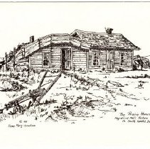
The Prairie Homestead Registered Nat'l Historic Site in South Dakota's badlands - 1981
(1) 5.0 x 7.0" notecard on heavy cardstock folded in half. On the cover of the card is a line and ink drawing of one story prairie "sod" house with a horse drawn plow in the foreground. Written in the lower right corner was the title "The Prairie Homestead Registered Nat'l Historic Site in South Dakota's badlands" and on the lower left "Rose Mary Goodson 1981". On the inside of the card was the following caption, "The Prairie Homestead is...
Record Type: Archive
-
True West Magazine Vol. 48 #6, August/September 2001 - 09/2001
(1) 8.0 x 11.0" doble sided glossy page magazine titled "True West". Entire magazine devoted to James Butler "Wild Bill" Hickok" with special editors Joseph G. Rosa and Thadd M. Turner. Part of Collection 2006.06 however the item was not listed in the auction bill of sale.
Record Type: Archive

-
United States National Forest Campground in the Black Hills, South Dakota / Spearfish Canyon and Vicinity - 1973
Side #1 11 x 17" double sided map titled "United States National Forest Campground in the Black Hills, South Dakota" adopted by Martin Murk from the Black Hills National Forest, South Dakota-Wyoming Shadow of the Sioux by the United States Forest Service, Department of Agriculture. Side #2 11 x 17" double sided map titled "Spearfish Canyon and Vicinity" adopted by Martin Murk from the Recreation Access Guide Map, South Dakota SD 3, South Da...
Record Type: Archive
-
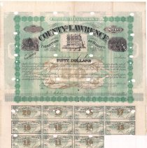
United States of America Territory of Dakota County of Lawrence Bond for $50.00 to J. Ringolskep - 07/01/1879
(1) 17 x 17" double sided United States of America Territory of Dakota County of Lawrence Bond for $50.00 to J. Ringolskep. This bond is number #05 sold to Ringolskep. The first nine coupons have been clipped from the bond certificate. A circular purple stamp is located on the document and reads" National City Bank N.Y. (New York) May 13, 6881 (1881?) PAID". There are a series of oval and circular holes throughout the document, null and voidin...
Record Type: Archive
-
Untitled - Lidar scans of the Deadwood Methodist Church Deadwood, South Dakota before demolition - 2002
(5) 24 x 36" pages containing 14 computer generated images of 321 Williams Street (Deadwood Methodist Church) before the demolition. Images created through lidar scanning conducted by Opteria under the direction of TSP Three, Inc. of Rapid City, SD. 01 - (6) 3D images recording the sides of the church from different angles. 02 - (6) 3D images recording close ups of architectural features on building 03 - Overview of church front and right l...
Record Type: Archive
-
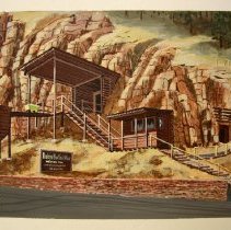
Untitled - Broken Boot Gold Mine Painting (Walt L. Williamson Memorial) by George Molestad - 1968
(1) 16 x 20" single sided painting of the Broken Boot Gold Mine entrance painted by artist George Molstad of Rapid City, SD. Painting was done in acrylic and a heavy cardstock. (1) 2.25 x 8.0" single sided metal sign that was originally mounted on glass of the frame. Metal plate is made from brass and engraved into the black surface. The metal plaque reads: "Walt L. Williamson Memorial. In memory and deep appreciation for 15 years of disti...
Record Type: Archive
-
Untitled - Days of 76 Chutes - Deadwood rodeo grounds - 1959
(2) pencil drawings of the proposed wood chutes for the Days of 76 rodeo grounds (Deadwood Amusement Park) Plan #01 - 10 x 35" single sided. Plan captures ten wood chutes and crows nest above the chutes 6 and 7. along left side written in pencil, "level of floor 5 feet off of ground with 18' tier in ..." On reverse written in pencil, series of numbers possibly figures of measurement. Plan #02 - 31 x 25" single sided. Plan is a three dimensi...
Record Type: Archive
-
Untitled - Jerome Harvey Homestead in Section 25 Township 3N Range 2E - 07/19/1950
(1) 17 x 22" photocopy map. Map is labeled "Jerome Harvey Homestead in Section 25 Township 3N Range 2E" and shows the location of the Little Rapid Ditch in relation to houses and outbuildings. Map also contains location of concrete sump and property boundaries within Section 25 Township 3N Range 2E.
Record Type: Archive
-
Untitled - Junction of Maitland Road and US Highway 14A - 07/19/1950
(1) 19 x 30" photocopy. Untitled map showing the junction of Maitland Road and US Highway 14A. From left to right, map contains Placer claim 42; Placer 288 and Chas Keene, Peter Kicken and John Landfried buildings; Placer claim 715 along with hill side road, rock loading trestle and Joe Savage home; Placer claim 64 and Julius Johnson cabins, rock crusher, rock loading platform and portion of Columbus Mill; Placer 255 and a portion of the Columb...
Record Type: Archive
-
Untitled - topographic map showing Belt City area (Lead, Deadwood, Central City, and Terraville - N/A
(1) 15 x 20" partial topographic map. This map is untitled but covers the following areas: Belt City area (Lead, Deadwood, Central City, and Terraville . Map provides locations of significant Homestake Mining Company buildings, prominent railroad lines, and names of gulches within and surrounding the Belt Cities.
Record Type: Archive
-
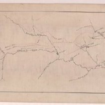
Untitled - water flumes in the Lead / Deadwood area - ca. 1880
MAP #01 17 x 42.5" untitiled velum map showing the communities of Lead, Deadwood, Central City and Pennington in association to Whitewood Creek and associated gulches. The focal point of the map are the water flumes (marked in red). These include: Montana Ditch, Arastra Ditch, Pioneer Ditch, Hearst Ditch, Deadwood Ditch and Boulder Ditch. Map also contains locations of mills including the DeSmet Mill, Terra Mill and Homestake Mills. ...
Record Type: Archive
-
Walking Tour Guide to Mount Moriah Boot Hill Cemetery - ca.1984
(1) double sided tourist map / walking tour guide titled "Walking Tour Guide to Mount Moriah - Boot Hill Cemetery" created by the City of Deadwood under the direction of Deadwood Commissioner Jerry Peret sometime between 1984 and 1987. On side #01 contains a hand-drawn map of the cemetery and locations of the 25 stops in the cemetery. Side #02 contains the narrative and biographies on the following individuals: James Butler Hickok, Potato ...
Record Type: Archive

-
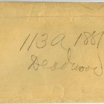
War Department, Signal Service, U.S. Army Official Business Envelope labeled "113a 1879 Deadwood" "113a 1880 Deadwood" and "113a 1881 Deadwood" - 1879,1880,1881
(3) 10.875 x 8.5" envelope titled, "113a 1879 Deadwood" "113a 1880 Deadwood" and "113a 1881 Deadwood" for the War Department, Signal Service U.S. Army. 1 of 37 reports donated to the City of Deadwood by the National Oceanic and Atmosphere administration in December of 2007.
Record Type: Archive
-
Water Conveyance System Homestake Mine Lawrence County, South Dakota - 07/1990
(1) 24 x 36" photocopy map titled "Water Conveyance System Homestake Mine Lawrence County, South Dakota" created by the HMC (Homestake Mining Company) Lead Office. Map shows large portion of Lawrence County laid out in Township, Range and Section. Focal point of map are the water systems, hydro plants, water ditches and water lines used by the Homestake Mining Company.
Record Type: Archive
-
Water Mains and Valves Yates Area (Green: Ellison Reservoir Red: West Lead Reservoir) - 10/13/1965
(1) 22 x 42" paper map titled "Water Mains and Valves Yates Area (Green: Water Mains and Valves Yates Area (Green: Ellison Reservoir Red: West Lead Reservoir))" created for the Homestake Mining Company of Lead, SD by Howard Mason. Map contains additional notes and the lines have been colored red and green pertaining to Ellison Reservoir (green) and West Lead Reservoir (red). Two of the areas have been enlarged showing flow direction.
Record Type: Archive
-
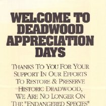
Welcome to Deadwood Appreciation Days
(1) 12 x 20" single sided advertisement poster that reads "Welcome to Deadwood Appreciation Days - Thanks to you for your support in our efforts to restore & preserve historic Deadwood, We are no longer on the "Endangered Species" list of historical places. Appreciation Days coupons accepted here". This was a promotional piece created by the Deadwood Chamber of Commerce. Along the bottom of the poster is a line drawing showing a two story, Vi...
Record Type: Archive
-
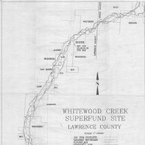
Whitewood Creek Superfund Site Lawrence County - unknown
(1) 17 x 22" map titled "Whitewood Creek Superfund Site, Lawrence County, S.D.". Map shows 100 PPM Isopleth boundary, tailing boundary, flood plain and property lines and owners last names along Whitewood Creek.
Record Type: Archive
-
Wild Bill Hickok Exhibit proof posters - 2007
(2) glossy "proof" posters produced by TDG Communications. Posters created to advertise the Wild Bill Hickok Collection purchased by the City in August 2006. Poster #1 10.25 x 14.25" single sided poster on glossy paper. Poster #2 12.0 x 18.0" single sided poster on mat finish
Record Type: Archive
-
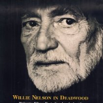
Willie Nelson in Deadwood Welcome Bikers Party Sunday August 8 Days of 76 Rodeo Grounds-Deadwood - 08/08/1999
(1) 17 x 22" color advertisement poster titled "Willie Nelson in Deadwood". The concert was held at the Days of '76 rodeo grounds on Sunday August 8, 1999. Focal point of the image is a facial shot of Willie Nelson followed by the advertisement, cost, location, etc beneath. The Deadwood shield logo located in center at the bottom of the screen. Photo courtesy Rocky Schenck scanned on 07/01/2016
Record Type: Archive
-
miscellaneous correspondence during the cataloging of Collection 2006.06
(13) 8.0 x 11.0" single sided emails and faxes. Correspondence relating to the cataloging of the Wild Bill Hickok Collection
Record Type: Archive