Archive Record
Images
Metadata
Title: |
Whitewood Creek Superfund Site Lawrence County |
Date: |
unknown |
Scope & Content: |
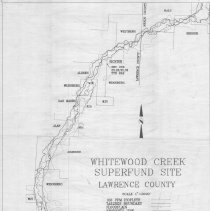
(1) 17 x 22" map titled "Whitewood Creek Superfund Site, Lawrence County, S.D.". Map shows 100 PPM Isopleth boundary, tailing boundary, flood plain and property lines and owners last names along Whitewood Creek. |
Collection |
2016.07 Lawrence County Planning & Zoning Collection |
Object Name: |
Map |
Catalog Number: |
MAP.XXXX.131.1 |